Silent, hovering, spider-like drones gliding across paddocks may seem like a take from a Hollywood sci-fi, but drones are becoming more commonplace on farms in Australia as their benefits start to be uncovered.
“New precision technology is revolutionising agriculture – and the widespread availability of low-cost, user friendly drones are providing farmers on all types of farms the opportunity to perform tasks that have previously been out of reach due to time, money or physical limitations,’’ says Dr Cheryl McCarthy, a mechatronic research fellow with the National Centre for Engineering in Agriculture, at the University of Southern Queensland.
In the last five years, drones have taken a big leap forward in affordability. Furthermore, they don’t require much training to pilot, and laws surrounding their use in agricultural operations are favourable. They are also strong enough to carry the kinds of remote sensing technology that, in the past, required satellite connectivity or the use of full-size, manned aircraft.
Other uses for drones, as being discovered by farmers from many different industries, include:
- Keeping Watch. Drones can act as a tool to monitor and uncover environmental changes on farm, or the health and status of livestock. Equipped with surveillance technology, drones can create time-series animations that report back any crop, land or herd issues in real time.
- More efficient and effective, targeted spraying. Drones equipped with sprayers and spray technology (including ultrasonic echoing devices and lasers) are helping reduce the environmental impact of chemical use on farms, reduce the overall spray requirement and target that spray to where it is really needed. Fast.
- Irrigation efficiencies. Drones fitted with remote sensing equipment can identify the driest sections of field so water can be applied much more economically and efficiently. They can also report back on irrigation performance, and help identify issues with infrastructure before big problems arise.
- Livestock surveillance. Drones fly over, in and around herds collecting all kinds of information from illnesses to pregnancies, young stock and injuries. In recent times, farmers have begun using livestock surveillance drones to monitor entire herd health and fertility cycles.
Over the last five years, Dr McCarthy has been researching the use of smart cameras fitted to drones that can capture imagery, transmit it to a central program and interpret imagery to generate reports, data and recommendations for farmers.
“Through funding by the Queensland Government, we have been able to develop technology that can be easily used by farmers, with little to no training or prior/assumed knowledge,” Dr McCarthy explains.
“The aim is for farmers to be able to deploy and fly the drone, collect imagery via the smart camera, and have an analysis and prescription produced for them that they can upload, say, to their sprayer, within hours.’’
She says the detail obtainable is “far and away’’ superior to that of manned flyover options or traditional crop walks.
‘’Imagery of weeds, canopy sizes, pastures, pest infestation and more can be obtained at a level of up to 6cm per pixel, so we can really get some quality information,’’ she notes.
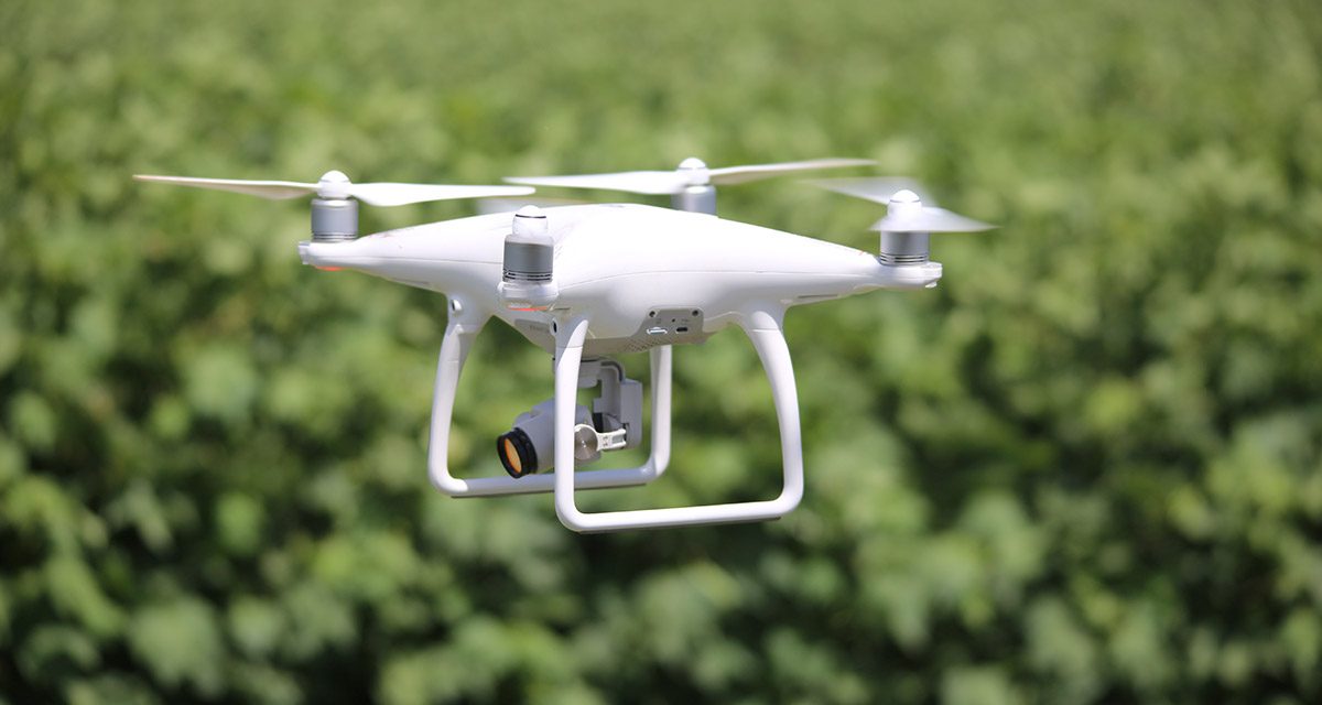
Dr McCarthy says her research has targeted low-cost set-ups, with drones weighing less than 2kg and costing around $1700 to $2000 – such as the DJI Phantom 4 drone (pictured) – coupled with the university’s smart cameras (expected pricing estimated at about $1500).
‘’For under $5000, a farmer could reliably deploy and collect data.’’
And it’s not just a low capital investment cost that farmers can benefit from, says Dr McCarthy, but potentially hundreds of hours of time freed up on-farm.
‘’There are some real time-saving benefits to this kind of technology; we flew a drone and camera set-up over a 25ha paddock in 15 minutes. The camera was able to collect and collate data and create a map within a few hours of the job.
“We learned from this flyover, that .5 percent of the paddock had weeds, with the images able to capture as close as 2cm resolution – so you can only imagine how long such a job would have taken on foot to record that level of reliable detail.’’
Dr McCarthy says that while the drones and camera set-ups are ‘‘almost ready to hit the market’’, the accompanying processing software is around 1 to 2 years away before it becomes commercially available.
For farmers using drones under 2kg for agricultural purposes, the Civil Aviation Authority requires a simple online form to be completed prior to commencing use.
‘’Farmers can fly drones up to 25kg – offering significantly more scope for tasks on the farm,’’ Dr McCarthy adds. ‘’There is potential to use drones in conjunction with spot sprayers, which has the potential to revolutionise weed control and save not only time, but a lot of money.
‘‘Drones are also used to monitor irrigation, with imagery able to tell exactly how efficient surface irrigation is and report back to the operator where levels lie in the field. Analysis software, once released, will then be able to chart or map the crop, row and distance of water travel and report back to the operator.’’
It might be early days in their adoption by the agricultural industry at large, but unmanned aerial vehicles (UAVs) are making their case; capable of taking some 2700 photographs in a 90-minute flight, helping farmers make decisions on crop, land and stock management, saving time and not least, being rather fun to use, drones may just be the next tool for your farm office.
For more information, contact
National Centre for Engineering in Agriculture, University of Southern Queensland, West Street.
Phone (07) 46312297 or mobile 0447133575